
The Inn is adjacent to Mt. Philo State Park and it’s intriguing geological history and abundance of wildlife.
Ecology
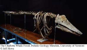
Fossils: in 1849, while constructing the first railroad between Rutland and Burlington, Vermont, workers unearthed the bones of a mysterious animal between Mt. Philo and the lake in Charlotte. Buried nearly 10 feet below the surface in a thick blue clay, these bones were unlike those of an y animal previously discovered in Vermont. After consulting with experts, the bones were identified as those of a "beluga" or "white" whale, an animal that inhabits arctic and subarctic marine waters in the northern hemisphere.
Because Charlotte is far inland (over 150 miles from the nearest ocean), early naturalists were at a loss to explain the bones of a marine whale buried beneath the fields of rural Vermont. Today, we can use the Charlotte whale to aid in the study of the geology and the history of the Champlain Basin.
Geology Mt. Philo is a well studied geological area, and is regularly visited by students from graduate college programs to 2nd graders. The Vermont Geological survey reports "The views of the Champlain Valley from the top of Mt Philo (elev. 968 ft) are exceptional. Much of the landscape has developed due to both erosion and deposition by glacial ice and meltwater. Vermont was heavily glaciated and once buried beneath ice. The glaciers carved away rock and ground it into finer grained sands and gravels, scoured valleys, and left behind rounded bedrock with grooves and striations. As the glaciers melted and retreated 12,000 years ago, ice dams and melting water formed lakes. Running water and melting ice deposited eroded material as deltas and moraines.
Mt. Philo geological formation-Vermont was heavily glaciated and once buried beneath ice. The glaciers carved away rock and ground it into finer grained sands and gravels, scoured valleys, and left behind rounded bedrock with grooves and striations. As the glaciers melted and retreated 12,000 years ago, ice dams and melting water formed lakes. Running water and melting ice deposited eroded material as deltas and moraines. The materials deposited at the surface help explain the history and evolution of the landscape. As the glaciers retreated from Vermont, Mt. Philo was an island in an inland sea as evidenced by the marine sand deposits at its base. The State Fossil, the Charlotte Whale, is believed to have died in a shallow marsh of the Champlain Sea and been covered by fine clay sediment, providing more evidence for changes in climate and history of the Lake Champlain area. Yet all this activity is recent when compared with the 550 million year old bedrock of the Champlain Valley.
Wikipedia says "It sits atop the Champlain Thrust fault of Middle Ordivician age. It is made up of difficult to weather sedimentary rock "the Cambrian Monkton Quartzites" that are thrust over younger Ordovician rocks of the Stony Point Formation. The rocks that hold up Mt. Philo were originally deposited during the Cambrian on a passive margin in a warm shallow marine shelf setting along the east coast of Laurentia (Proto North America). These rocks have subsequently been thrust west during the Taconic Orogeny (~450 Ma) and perhaps again during the Acadian Orogeny (~350 Ma).
Geology
Alice Outwater says: Lake Champlain started forming 600 million years ago. A trough was formed when the tectonic plates that had collided one billion years ago (causing the uplift that formed the Adirondack Mountains) pulled apart (Harris, 1990).
The massive Wisconsin glacier covered all of New England 15,000 years ago and more than a mile of ice capped portions of northwestern Vermont. These millions upon millions of tons of ice depressed the earth's crust, bringing it below sea level. Some 12,500 years ago the glacier retreated north of the St. Lawrence lowland. Glacial striations and glacial till are still visible where the Pleistocene glaciers were funneled by the lake trough and then retreated. Large rocks remaining from the glacial till are called erratics and can be found dotted along the southern shoreline.
As the glacier retreated, saltwater flowed in from the Atlantic Ocean to fill the depression that is now the St. Lawrence Seaway. The Champlain Sea was created. An arm of the sea extended into what is now known as the Champlain Valley where it remained for approximately the next 2,300 years. A skeleton of a Beluga (also known as White) whale (Delphinapterus leucas), believed to have lived 10,000 to 12,500 years ago, was found a mile inland from the Point and serves as proof (Howe, 1997). Many of Vermont’s 77 native fishes arrived at this time (Langdon, Ferguson & Cox, 2006).
Released from the great weight of the ice, the ground slowly rebounded, and the ocean water began to flow north. It was replaced by fresh water melting into the valley and eventually the Champlain Sea disappeared. Lake Champlain has existed in its present form for about 9,000 years (Howe, 1997). It exits across the extensive deposits of glacial sand and silt that once covered the bottom of the Champlain Sea through the Richelieu River flowing north into the St. Lawrence Seaway to the Atlantic Ocean. The deepest part of the trough lies between Thompson’s Point and Split Rock, where lake bottom is 400 feet below the lake surface and bedrock is 1000 feet below.
The rock type is sedimentary dolostone, a grey-black limestone-like stone which is high in calcium and magnesium-carbonate. Thompson’s Point is the type location of the youngest formation, Cutting dolostone, which is the only dolostone horizon to hold fossils. The fossils are a small snail, Ophileta, of which only casts remain. (For further description of dolostone see Harris, 1990.) Flint lies between the layers within the dolomite.
Today, Thompson’s Point is a peninsula of land on the Vermont side, about 1.5 miles long, easily recognized from the Lake, air, and land[1]. The Point is clearly defined by its bedrock base - 40 foot bluffs on the northwest shore that gently descend to a ledge on the south shore (Harris, 1990). The tip of the Point marks the deepest part of the Lake (130 meters). On either side of the Point are wide bays. Converse Bay to the north is moderately deep (4 to 100 meters), with a stone and pebble base. Two small islands are in it. No significant streams or rivers flow into it. The southern bay called Town Farm Bay is more shallow (1 to 22 meters) with more inlets and small bays. The base of the bay is filled with a marsh into which Thorpe and Kimball Brooks enter. The far side of the bay is another larger marsh through which the waters of a river (Otter Creek) and Lewis and Little Otter Creeks enter the Lake. The area is ideal for different life stages of many kinds of fish because of the confluence of different habitats—rivers, large and small bays, rocks and shoals, and wetlands—within a shallow bay next to the deep cold waters of the trough. Town Farm Bay has been considered one of the two most important fishing grounds in Lake Champlain since pre-historic times.
Animals
Many Vermont native animals can be found on Mt. Philo. According to noted animal biologist, Laura Farrell bobcats and coyotes roam through the park on their daily rounds. Fisher cats are secretive, but have been regularly spotted. Red fox have dens in easily accessible areas. Deer are plentiful on certain sections of Mt. Philo. Rabbits have had significantly increased numbers in the last 2 years, and our wild turkey population has also increased. Evidence of porcupines and raccoons are often found Pests include skunks and groundhogs, though neither is in great number. There are no poisonous animals or insects on Mt. Philo, and rare moose and bear sightings. Red salamanders and mudpuppies are plentiful in the spring.